
Educational trails
In the educational infrastructure of the Karkonosze National Park, there are 10 educational trails that have been identified and marked. When roaming the chosen path, we encounter specially prepared theme stops. Each of them has an educational desk. Our paths play a special role: they are an irreplaceable form of implementation of active educational methods, throughout the direct contact with nature. Individual tourists and groups who do not appreciate educational activities with the assistance of our park staff, can still enjoy this way of gathering interesting information about the KNP. Therefore for those who prefer to encounter everything by themselves we provide our guests with educational desktops and colorful guidebook. Guides are available free of charge at the Park’s educational facilities along with headquarters of the Park in Jelenia Góra - Sobieszów.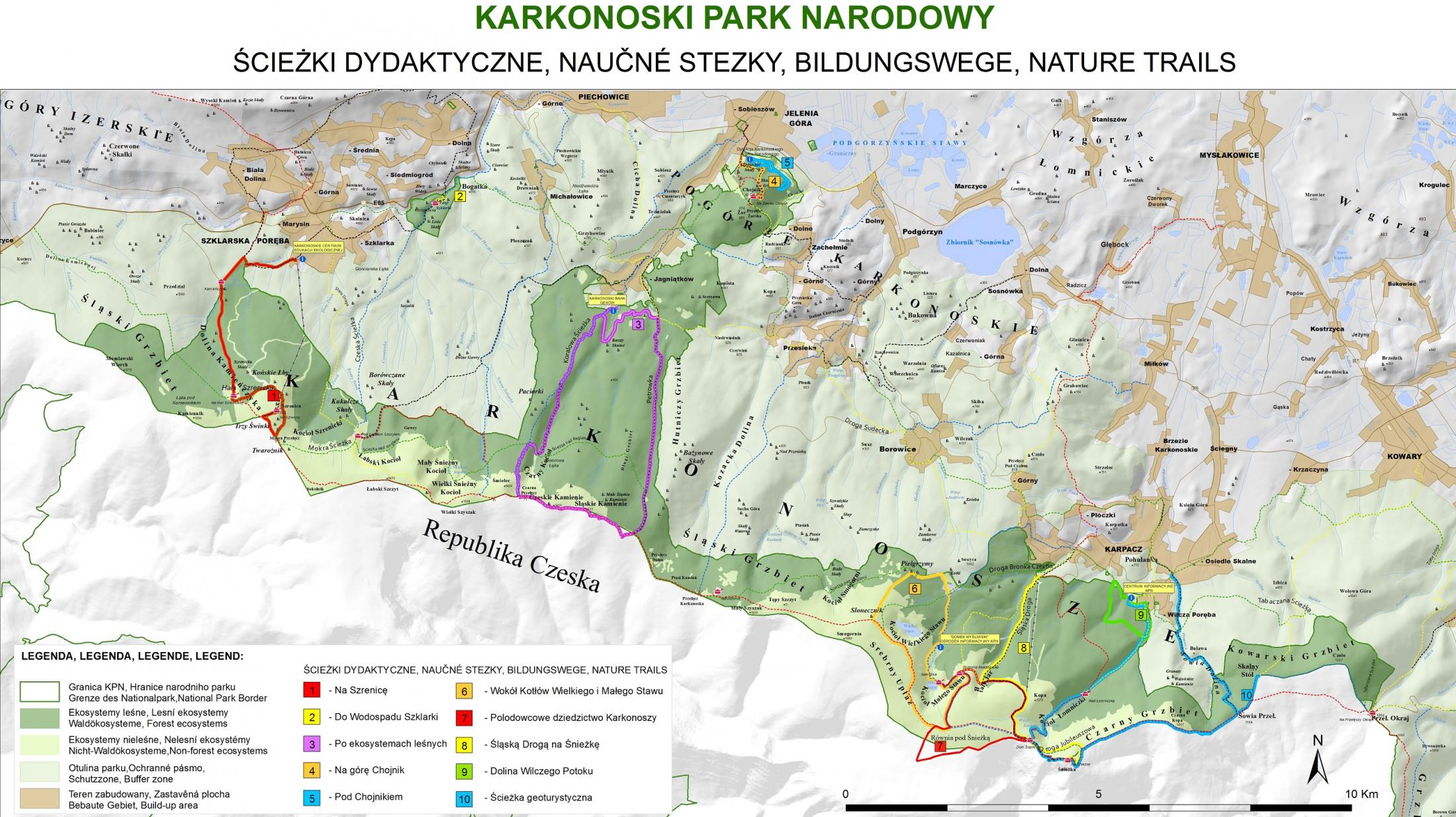
1. The educational path "Szrenica"
The path is marked within the area of the Karkonosze National Park and the State Forests. Its course corresponds with the marked hiking trails. There were 16 didactic points on the path. Along the path of the hike one will learn about the flora and fauna of the three vegetation floors of the: foothills, mountain level and subalpine floor.
The safest time to use the trail: April to October.
Total path length: 12 km.
Altidudess: Karkonosze Ecological Education Center KNP 718 m. asl. - Szrenica 1362 m. n.p.m.
Vertical difference: 644 m.
Walking time: 5-6 hours.
The course of the path can be found on the Geoportal of Giant Mountains
Download the guide here
2. Szklarka Waterfal Path - adapted for the disabled
The path has a viewing platform for those on the wheelchairs. The path consists of three pedestrian stops, presenting the most characteristic features of Karkonosze nature: steep slopes, Szklarka riverbed, along with the rocks of the river’s course. It presents lower mountain zone communities (500-1000) Sudeten beech with fir and spruce, various mosses, lichen, along with the variety of birdlife – and of course – Szklarka Waterfall itself.
The safest time to use the trail: April to October.
Path length in total: 375 m.
Altidues: 503 m asl, parking - 514 m asl – Szklarka Waterfall
Vertical difference: 11 m.
Walking time: 7 to 20 minutes in one direction.
The biggest slope of the path: 17%.
The course of the path on the Geoportal of Giant Mountains
Download the guide here
3. KNP forest ecosystems educational path
The path starts its course at the Karkonosze National Park Life Gene Bank in Jagniątków. The path is twofold . The course of the path corresponds with the tourist trails of the Park and uses roads and forests paths. On the path we can learn about the functioning of the KPN Life Gene Bank.
The safest time to use the trail: April to September.
Path length in total: approx. 15 km
Altidues: Jagniątków - 615 m. asl. - state border 1417 m. sasl
Vertical difference: 802 m.
Walking time: about 7 - 8 hours.
The course of the path on the Geoportal of Giant Mountains
Download the guide here
4. The "Chojnik Mountain" Educational Path
The path runs through the Chojnik Mountain. There are 10 stops. From entrance gate to Karkonosze National Park through Zbójeckie Skały , Skalny Grzyb , until the ruins of Chojnik Castle. The path runs its course entirely in the Karkonosze National Park and concurs with the hiking trails. On this very path we have a rare opportunity to walk among the natural tree stands that formerly dominated the lower valley in the Giant Mountains. It is a beautiful beech forest, with a mixture of other tree species as well.
You can use the track all year round.
Path length: 2.5 km (one way).
Altitudes: KPN entrance gate - 400 m.asl - ruins of Chojnik castle - 627 m. asl.
Vertical difference: 227 m.
Walking time: about 3 - 4 hours to the castle and back.
The course of the path on the Geoportal of Giant Mountains
Download the guide here
5. Path below Chojnik – a trail for children and youngsters
The path is set in three mutually complementary variants. It starts and ends at the KNP Headquarters.
Varian 1 the Forest Gates - length 800m. Duration of the lesson 1 - 2 hours. The path is dedicated to small (kindergarten to I-III primary school). On this path kids can learn about the effects of erosion, learn about the trees, forest and meadows ecosystems, as well as conduct simple field research.
Variant 2: Treasures of the history. Length 1700 m. Duration of classes: from 2 to 3 hours. The path is designed for children and young people of primary and secondary schools. We learn to recognize tree species, we observe sequences of ecological processes, the circulation of matter in nature. We learn some of the history of the region while visiting Richard Cogho family cemetery. During "Green Class" lessons we also learn how to help the wildlife of the Karkonosze National Park. There is also a possibility of conducting a field research.
Variant 3 - "A Rouge Road" - length 2800 m. Duration of the lesson from 3 to 4 hours. This is a trail dedicated to more experienced young naturalists. We get to know the changes within the tree stands, the different types of lichen, unique rock formations. We also learn how to use the landmarks on our way. We get to know about the importance symbiotic organisms along with the bioindicators.
Warning! The path is inaccessible to the normal tourist traffic. It is set outside the tourist trails. You can use it only after consultation and in the presence of educational workers of the KNP.
Download the guide here
6. Around the Little and the Big Pond
The path begins at the KNP Glade and leads through the rocks of the Pilgrims, Sunflower Rock, the edge of the Great and Little Pond, the Crossroads of the Burned Watchtower, Biały Jar, Strzecha Akademicka Shelter, Samotnia Shelter, then the "Hunter's Lodge" the Informational and Educational KPN Center, through the valley of Pląsawa River –ending at its drain. The path (exluding Marmit – Studzienka stop) runs entirely in the area of the Karkonosze National Park and corresponds with the course of hiking trails.
Path length in total: 12.7 km (from the glade).
Altitudes: from 1050 m asl. On the glade - the circle near the burnt-out watchtower 1430 m asl. - Marmit about 770 m asl.
Vertical difference: 660 m.
Walking time: 5 - 6 hours.
The course of the path on the Geoportal of Giant Mountains
Download the guide here
7. "Glacial heritage of the Giant Mountains" - cross-border path.
The path runs through the area of the Karkonosze National Park (Poland) and the Krkonošský národní park (Czech Republic). It consists of 9 didactic points 5 in KNP and 4 in KRNAP. The course of the path coincides with the existing tourist routes and two pedestrians border crossings spots: "Silesian House" and "Równia pod Śnieżka - Lučni bouda".
Path length: 8 km.
Altitudes: "Samotnia" shelter 1200 m. asl - "Crossroads at the Burning Watchtower" 1430 m. asl
Vertical difference: 230 m.
Walking time: 5-6 hours.
Each educational site has an information desk in three available languages: Polish, Czech and German.
The course of the path on the Geoportal of Giant Mountains
Download the guide here
8. "The Silesian Way to Snieżka Mountain"- educational path
The trail starts its course at the Biały Jar buss stop in Karpacz and leads to the Śnieżka Mountain – like shown on the Map above (nr 8 – the yellow color route). The path runs through all vegetation floor levels of the Giant Mountains - from the foothills, through lower mountain zone – up to the the subalpine floor, and eventually - the alpine floor. It is easy to notice - that the higher we go, less flora and fauna we can spot. This is the very characteristic feature of the mountainous regions. While walking the path, let us remember the tragedy that happened here on March 20th, 1968. A falling avalanche killed 17 tourists then. The Giant Mountains, despite their gentle appearance, may very well become a thrillingly dangerous place.
When to use the path? The safest time to use the track is from May to September.
Path length in total: 6.7 km (one way).
Altitudes: .-Bus stop "Biały Jar" - 760 m asl, Śnieżka - 1602 m.
Vertical difference: 842 m.
Walking time: 2 - 3 hours with stops plus 2 hours back.
The course of the path on the Geoportal of Giant Mountains
Download the guide here
9. Through the Valley of Wilczy Potok (Wolf Creek)
The path is a loop leading from KPN Information Center in Karpacz, along the green trail to Dom Urszuli (Ursula’s Hut), followed by the Ursula Road to the yellow trail above the Lomniczka Stream and by the yellow trail – back to the KPN Building again. The footpath is fully accessible to pedestrians and partially (the Ursuline Way) for cyclists. While wandering the path we have the best opportunity to learn about the the specifics of the Karkonosze meadows, the role of dead wood in nature, we will find out what is the purpose in cloning the fir tree in the Karkonosze National Park, and how do we care for wild animals. On the path we can also admire the beauty and strength of mountain streams, slowly carving rocky ground on its way. There are eight information stops on the path.
The safest time to use the trail: April to October.
Path length in total: 3.5 km.
Altitudes: KNP Information Center 700 m. asl - Ursula Road 750 m. asl
Vertical difference: 50 m.
Walking time: 1.5 - 2.5 hours.
The course of the path on the Geoportal of Giant Mountains
Download the guide here
10. The Eastern Giant Mountains Geotourist trail
There are fourteen information stops on the path. The path leads through exceptionally interesting geotouristic areas of eastern Karkonosze. While roaming the path we will get acquainted with the geology and geomorphology of this Karkonosze region.
The safest time to use the track: May to September.
Path length in total: about 17km.
Altitudes: KPN Information Center – 700 m asl. Snieżka Mountain. 1602 m. asl
Difference levels: 902 m.
Walking time: about 8 hours.
The course of the path on the Geoportal of Giant Mountains
Download the guide here
More information: here
 Public Information Bulletin


